A hybrid path design combining new construction and improved existing trails is the preferred option for the Mad River Valley Active Transportation Corridor. The first phase of implementation will focus on a 1.1-mile segment between Warren Village and Riverside Park.

A newly completed scoping study recommends this hybrid design approach for the Mad River Valley Active Transportation Corridor. It combines newly constructed shared-use path segments with upgrades to existing trails.
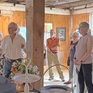
The Mad River Path Association and the Mad River Valley Planning District will present the findings of the active transportation corridor scoping study and outline next steps at a public meeting and celebration on Wednesday, October 1, at 5:30 p.m. at Lareau Pavilion at Lareau Farm and Forest in Waitsfield.
The event will feature interactive displays, food, children’s activities, and a presentation of the final report and implementation plan.
“This hybrid model is a smart, flexible approach that prioritizes safety and connectivity,” said Misha Golfman, executive director of the Mad River Path Association. “We’re excited to begin moving toward implementation, starting with a segment that has the potential to dramatically increase regional connectivity.”
The cost of this first segment is $2 million, Golfman said and added that several grant applications are in the works for the project.
“We will begin improving existing path sections between Warren and Waitsfield in 2026. The construction of Ellen Lane to Riverside Park Path along Route 100 will take place in 2028, provided we receive the federal bike and pedestrian grants,” he reported.
The hybrid recommendation follows a comprehensive scoping study funded by an $84,000 Transportation Alternatives Program grant. The study builds on the 2016 MRV Moves Active Transportation Plan, which laid out a vision for a connected system of trails, sidewalks, and road improvements linking villages, schools, businesses, and recreational areas across The Valley.
COMMUNITY BACKING
The study evaluated three alternatives:
- Alternative A: Improve existing trails only.
- Alternative B: Add widened bike lanes along Route 100/100B.
- Alternative C: Build a fully separated 10-foot-wide shared-use path.
Community input played a key role in determining the final recommendation, Golfman said. At two public meetings, over 200 residents cast a total of 280 votes, with 218 (78%) supporting Alternative C – the most ambitious and safest option.
Ultimately, the scoping study identified a hybrid approach as the preferred path forward. This combines the construction of new 10-foot-wide shared-use paths in critical areas with upgrades to existing trails where feasible.
“This level of community support sends a clear message,” Golfman said. “People in The Valley want a safe, separated path that connects where we live, work, and play.”
PHASED PLAN
Implementation will be phased, prioritizing “low-hanging fruit” – short new segments that unlock longer continuous routes by bridging existing gaps.
Key strategies of the hybrid model include:
- Reuse and improvement of existing sidewalks in village centers.
- Interim solutions at bridge crossings.
- Boardwalks through sensitive ecological zones.
- Flood-resilient design approaches.
“This is about working with the land and our communities, not against them,” Golfman said. “It’s a long-term commitment, but one we believe the entire valley is ready to embrace.”
While construction timelines are still being developed, naming the Warren-to-Riverside Park segment as the first phase gives planners and the public a clear starting point.
For updates and additional information, visit madriverpath.org.
You might also like